- The Aravallis, India’s oldest mountains, have been under threat due to development forces.
- The new classification on categorising the mountains based on their height, issued by the Ministry of Environment, Forests and Climate Change and endorsed by the Supreme Court, adds an extra dimension of threat to the Aravallis.
- Geologist C.P. Rajendran writes in this commentary on the geological and ecological significance of the Aravallis, and the dangers that the new order poses.
Stretching approximately 700 km across the Indian states of Haryana, Delhi, Rajasthan, and Gujarat, the Aravalli mountain range is a spectacular geomorphic feature in northwestern India. It forms a distinct central ridge, with the Thar Desert to its west and the Malwa Plateau to its east and serves as the source for rivers including the Banas, Luni, Sakhi, and Sabarmati. Its highest peak is Guru Shikhar, which rises to 1,722 meters near Mount Abu in Rajasthan. Historically, the western and eastern regions of the Aravallis gave rise to the distinct cultural domains of Marwar and Mewar, from which the Marwari and Mewari communities originate. India’s Rashtrapati Bhavan, situated on Raisina Hill, is part of the Aravalli ranges.
The Aravallis are not only the subcontinent’s most ancient mountain chain but also preserve a remarkably continuous, three-billion-year (3 Ga) record of Precambrian evolution (approximately 3.6 to 0.6 billion years). This history is encapsulated in three major chrono-stratigraphic (rock layers based on their relative age) terranes (a block of Earth’s crust bounded by geological faults): the Basement Banded Gneissic Complex, the Aravalli Supergroup, and the Delhi Supergroup. Each terrane possesses a distinct history of craton (crust) formation, development of depressions, deformation, movement of molten rocks, transformation into new rock types, and concentration of economically valuable minerals.
Thus, formed during the Proterozoic Eon (2.5 to 0.5 billion years), the Aravalli mountain belt is Earth’s oldest surviving mountain system—a geological relic distinct from the nearby, much younger Himalayas. It reflects some of the planet’s earliest tectonic processes and acted as a rigid continental “backstop.” This ancient cratonic block later influenced the formation of northern India’s geology by providing a stable margin against which the Himalayas collided.
The Indian craton (“proto-India”) formed over billions of years through ancient plate tectonic processes. It is an amalgamation of several Precambrian cratonic nuclei, separated by suture zones, rifts, and mobile belts, which accreted into a largely stable configuration by approximately 2.5 Ga. The principal cratonic nuclei (microplates) that form the Indian Shield are: Dharwar Craton (split into Western and Eastern Dharwar), Singhbhum Craton, Bastar Craton and Aravalli-Bundelkhand Craton (split into Aravalli and Bundelkhand blocks).
The assembly of “proto-India” was a polyphase process driven by ancient plate tectonics, involving arc accretion, inter-continental collisions, and repeated episodes of magmatism (movement of molten rocks), metamorphism (transformation into new rock types) and deformation.
Ancient mountains
This protracted orogenesis (mountain formation) is recorded in several major Indian Precambrian fold belts. The formation of the Aravalli-Delhi belt was contemporaneous with that of the Satpura belt, the Central Indian Tectonic Zone, the Eastern Ghats Mobile Belt, and the Southern Granulite Terrain. All these belts underwent multiple cycles of continental collision, subduction, and cratonic accretion primarily during the Proterozoic Eon (2500 to 538 million years, ago).
Consequently, these belts represent ancient suture zones—the scars of Precambrian plate tectonic processes that ultimately forged the stable architecture of Peninsular India. This consolidated craton later played a crucial role in the assembly and breakup of supercontinents, including Columbia, Rodinia, and Gondwana.
The Aravalli Range is widely considered to have formed from the collision between the Bundelkhand and Marwar cratons during the Mesoproterozoic times (1600 to 1000 million years ago). Its eastern margin is delineated by the Great Boundary Fault (GBF) and the Vindhyan Basin, bordered by the Bundelkhand Craton. To the south, its boundary is defined by the Son-Narmada-Tapti Lineament, demarcating the northern limit of the Central Indian Tectonic Zone. The Aravalli and Vindhya ranges converge at Ranthambore, the site of the UNESCO-listed fort, near the town of Sawai Madhopur.
Geologists have reconstructed a geological timeline for the evolution of the Aravalli mountain belt. The first major tectonic cycle began around 2.2 to 2.1 billion years ago, with rifting within the Mewar craton. This crustal stretching triggered mantle-derived volcanism, signalling the initial rupture and birth of an oceanic basin.
This ocean persisted until approximately 1.8 to 1.7 billion years ago, when tectonic forces reversed. The basin closure led to compression, which crumpled the accumulated sedimentary and volcanic sequences into a fold belt, generating granitic melts. This collisional event marked the culmination of the cycle, establishing the first major orogenic structure in the region.
Following the stabilisation of the Aravalli Fold Belt, a second major rifting event occurred to its west, creating the Delhi Basin. This basin underwent a prolonged and complex tectonic history, involving sedimentation, volcanism, and eventual closure, which ultimately evolved into a mountain range. This nearly billion-year-long event culminated around 700 million years ago. It formed the younger Delhi Fold Belt as a westward extension of the ancient Aravalli mountain system.
A central conflict between deep time and contemporary threats has now emerged. Having endured for billions of years, the ancient Aravalli mountains now face a distinctly modern, anthropogenic threat. While natural processes like erosion and sedimentation have gradually shaped these hills over millions of years, human activity now dramatically accelerates their degradation. The statistic that humans move 24 times more material than all the world’s rivers combined is staggering. Humanity has become the dominant geomorphic force on the planet’s surface, surpassing natural processes in scale and speed. This undeniable shift is the essence of the Anthropocene concept, which remains a powerful cultural and scientific framework for understanding our time.
An elevation threshold that undermines conservation
Following directions from the Supreme Court of India, a committee led by the Ministry of Environment, Forest and Climate Change (MoEFCC) was formed. In a controversial move, this panel has introduced a new “elevation threshold” of 100 meters above the local relief for a landform to be considered part of the Aravallis – based on the Richard Murphy landform classification system – as a uniform standard across all Aravalli states (Delhi, Haryana, Rajasthan, and Gujarat). This classification has been formally used by the Rajasthan government since 2006, based on a 2002 state committee report.
Like other landform classifications, using various variables, Richard Murphy’s classification system, detailed in his 1968 work Landforms of the World, is a comprehensive, hierarchical framework for understanding Earth’s surface features. It integrates three independent variables: 1) Structure: The underlying geology, including rock type, age, and tectonic activity; 2) Topography: The surface form, characterised by relief and slope; and 3) The process: The erosional and depositional forces (e. g., climate, glaciation) that shape the landscape.
The system employs quantitative measures, defining landforms with over 300 meters of local relief as mountains and those with 90-300 meters as hills. However, a critical distinction has been overlooked by Indian authorities: that this is a purely academic framework designed for systematic analysis and mapping. It was never intended to earmark land for commercial activities like mining and real estate expansion.
The distinction between a hill and a mountain is often region-specific. In regions like Rajasthan, Delhi, or Haryana, these landforms – irrespective of their absolute height – perform vital ecological functions within the landscape. They act as watersheds, climate regulators, and biodiversity corridors. Reducing their protection to a rigid, imported height threshold ignores their local ecological and geographical roles, prioritising commercial convenience over systemic environmental integrity. Consequently, vast tracts of low hills and ridges would lose their previous legal protections, opening them to rampant sand mining and real estate development.
On November 20, the Supreme Court accepted this elevation-based definition and ordered scientific mapping alongside a “sustainable mining plan” before granting new leases. This judicial ruling effectively overturns previous notifications that recognised the Aravallis as ecologically sensitive and established curbs on illegal mining and encroachment. Conservationists have condemned recent ruling as a reckless decision.
The conflict stems from two competing definitions. The Forest Survey of India’s geomorphic definition, endorsed by the Supreme Court’s own Central Empowered Committee (CEC), classifies hills with a slope of over 3 degrees as part of the Aravallis. This encompasses the lower hills that are excluded by the Ministry of Environment’s stricter 100-meter height threshold. By accepting the latter, the Court has effectively removed vast ecologically sensitive areas from legal protection.
Once adorned with lush greenery, the Aravalli hills have been gouged into a landscape of deep ravines. The fierce, relentless blasting used to shatter rock has driven away the region’s abundant wildlife. Crusher operators illegally tunnel into the hillsides using gunpowder and compressors. The massive explosions shatter the peace of nearby villages, where residents live in constant fear. Cracks spiderweb across their homes and water tanks, a daily reminder of the looming threat of collapse.
The fallout is pervasive: pollution from explosions, clouds of sand and silica from crushers, and choking dust from overloaded transport vehicles are severely impacting public health. While mine owners obtain the necessary permits from the environment ministry, their operations consistently violate the very standards they are supposed to uphold. The excavation proceeds not with regulation in mind, but with reckless disregard for both law and landscape.

A critical ecological function
To the untrained eye, these hills may appear as degraded forest patches at the urban fringe, but they collectively form a vital natural barrier. Their destruction would cripple groundwater recharge and dismantle the critical wall that blocks desert sands from the Thar Desert. This directly threatens the National Capital Region – already suffering from the world’s worst air quality – with long-term desertification.
The Aravalli Hills, irrespective of elevation, performs a series of critical, interconnected ecological functions. It acts as a natural barrier, arresting eastward desertification from the Thar and shielding the Gangetic plains from the full force of Central Asia’s westerly winds. This positioning also makes it a crucial climate regulator; it influences the trajectory of monsoon clouds towards the lower Himalayas, ensuring vital rainfall that supports rich biodiversity, agriculture, and livelihoods across northern India.
Furthermore, the range mitigates the impacts of human activity. It helps dissipate the power and frequency of dust storms and, despite its own diminished forests, continues to serve as a vital buffer for urban landscapes, absorbing the strain and shock of anthropogenic pollution and development.
The past is key to the present – a timeless dictum cherished by geologists. Today, we are witnessing a paradigm shift so profound that it has swept us into the uncharted waters of a new and unusual stage in Earth’s history. We are entering a geological epoch in which human activity rivals natural forces in shaping the planet’s surface.
The potential transformation of the Aravalli Range exemplifies this shift in agency. Its future will have profound consequences for northern India, especially against the backdrop of intensifying climate change and rising temperatures.
Citation:
- Ghosh, S., D’Souza, J., Goud, B. R., & Prabhakar, N. (2022). A review of the Precambrian tectonic evolution of the Aravalli Craton, northwestern India: Structural, metamorphic and geochronological perspectives from the basement complexes and supracrustal sequences. Earth-Science Reviews, 232, 104098. https://doi.org/10.1016/j.earscirev.2022.104098.
- Rogers, J. J., & Santosh, M. (2001). Configuration of Columbia, a Mesoproterozoic Supercontinent. Gondwana Research, 5(1), 5-22. https://doi.org/10.1016/S1342-937X(05)70883-2.
- Fareeduddin & Banerjee, D.M., (2020). Aravalli Craton and its Mobile Belts: An Update. IUGS, Vol. 43, No. 1, p. 88-107. https://doi.org/10.18814/epiiugs/2020/020005.
- Gupta, H. (2022). Geographical analysis of environmental crisis and conservation in Aravali mountain region. IOSR Journal of Humanities and Social Science, Volume 27, Issue 9, Series 1.
The author is an adjunct professor at the National Institute of Advanced Studies, Bengaluru, and the director of the Consortium for Sustainable Development, Connecticut, U.S.A.
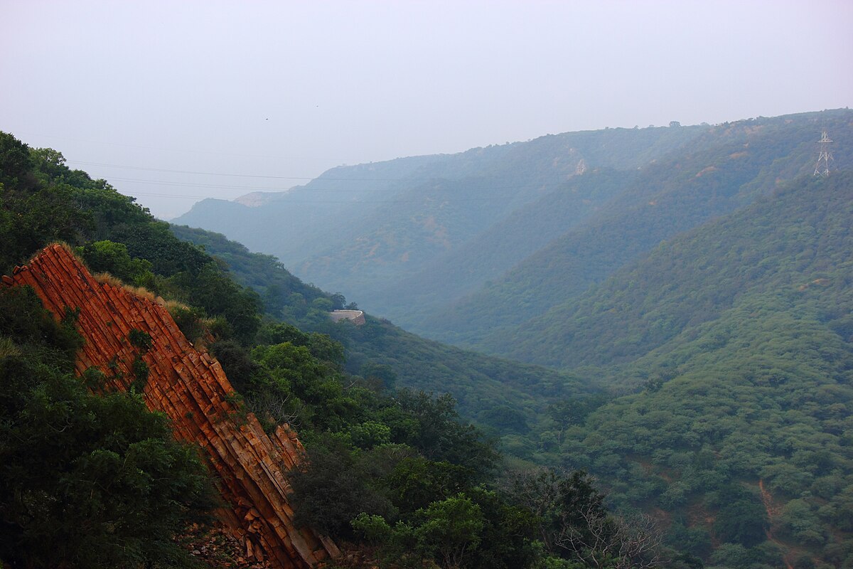
Banner image: The Aravalli mountains in Rajasthan. Image by Mayank Bhagya via Wikimedia Commons (CC BY 2.0).