More than a decade after Malaysia Airlines flight MH370 went missing after veering thousands of miles off course, its location remains unknown.
The Malaysian government has promised to pay a private company, Ocean Infinity, $70m (£56m) to search for the plane on a “no find, no fee” basis.
The company intends to target a 15,000 sq km (5,800 sq mile) area in the Indian Ocean where it is thought there is the highest likelihood of finding the missing aircraft.
What do we know so far?
Flight MH370 was carrying 12 Malaysian crew and 227 passengers when it took off from Kuala Lumpur on a routine flight to Beijing, shortly before 1am on 8 March 2014.
At 2.22am, after turning west, away from its planned route, the Boeing 777 vanished from radar coverage while over the Andaman Sea.
Satellites continued to receive hourly signals from the plane – indicating it was still flying – until just after 8am, when it is believed to have run out of fuel.
These hourly signals have been used to triangulate the distance between a satellite and the plane, but this can only place it within a search zone of 120,000 sq km (46,000 sq miles) of the southern Indian Ocean.
“It’s a monstrously big circle,” says Simon Maskell, professor of autonomous systems at Liverpool University and a former scientific adviser to Ocean Infinity.
Numerous parts and debris have been found around the shores of the Indian Ocean and identified as belonging to MH370, including pieces of the wing, tail, cabin and engine. No human remains have ever been found but everyone onboard is presumed dead.
What is Ocean Infinity?
A marine robotics and seabed survey company, based in the UK and the US, “with a track record of finding things that are difficult to find on the ocean floor”, says Maskell.
The company is best known for providing the Falklands Maritime Heritage Trust with submersible experts and underwater robots that helped to locate Sir Ernest Shackleton’s lost ship Endurance in 2022.
In 2018, Ocean Infinity unsuccessfully searched more than 80,000 sq km of ocean for MH370. Now, it is determined to try again.
What equipment will Ocean Infinity use?
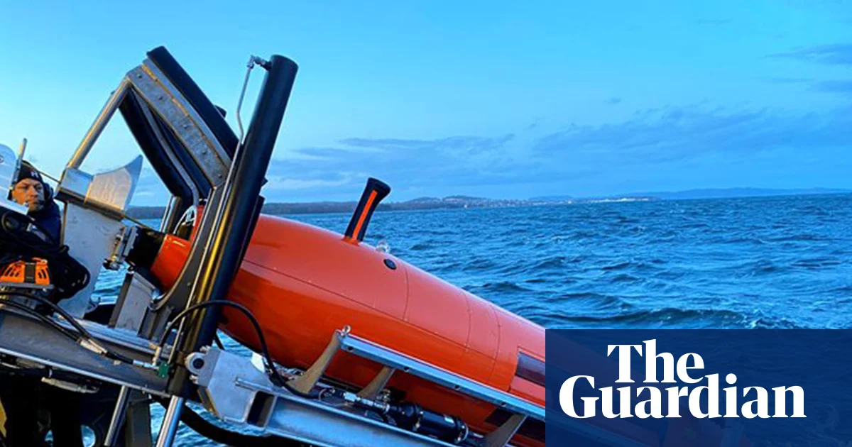
The company has a fleet of Hugin 6000 autonomous underwater vehicles (AUVs), which can create a 3D map of the ocean floor at depths of up to 6,000 metres using sonar, laser, optic and echo sound technology, with each machine estimated to be worth at least $8m.
Despite operating in the dark, the fleet can capture sonar images of their surroundings by bouncing acoustic pulses off whatever is nearby and using lasers to scan unidentified objects (known as “points of interest”) and create detailed 3D images.
Each free-swimming AUV can be operated remotely but is mainly used to carry out assignments independently of an operator, and then return to the surface. It can stay underwater for 100 hours before its battery runs out.
“You can say: make me a map of that area and come back when you’re done,” says Maskell.
What will happen if a piece of the plane is found?
Each AUV is able to send limited samples of the data it collects – such as detecting a “point of interest” – to a surface ship and receive mission updates from operators who are supervising its progress using an acoustic communications system.
“It [the AUV] uses a sub-bottom profiler to see how much sediment there is and how far you have to go down to get to solid rock seabed,” says Richard Godfrey, an independent aviation investigator. “It also has a magnetometer so it can detect metal, even if it’s buried under several metres of sediment.”
If necessary, the surface ship can also send down remote-operated vehicles (ROVs) to train floodlights on an object so it can be filmed and photographed.
These have robotic arms that can also be operated remotely so the machine can grab, turn and inspect objects. It can also bring smaller objects back to the surface.
How big is the search area?
Ocean Infinity began searching the 15,000 sq km area priority area in February, but called off the expedition in April after 22 days due to poor weather conditions. It will resume on 30 December for 55 days.
Godfrey estimates the company has already searched nearly 10,000 sq km, and is planning to search another 25,000 sq km, after spending “tens of millions of dollars” on ships and equipment.
“I don’t think they’re in this for the monetary reward of $70m, because this search is very, very expensive. I think they’re in this for the achievement and their ability to market themselves as the greatest underwater-search firm in the world because they found MH370,” he says.
What are the biggest challenges?
“The ocean floor is a very complicated environment to navigate around,” says Maskell. “It’s not just flat. You’ve got huge mountains, ridges and chasms – and you’ve got to look everywhere.”
In the Indian Ocean, there are canyons more than 300 metres (1,000ft) deep, cliff faces suddenly rising thousands of metres feet off the sea floor and active volcanoes to watch out for, says Godfrey.
Although the area Ocean Infinity is searching has been surveyed previously, it is thought that the data might be incomplete. “This is not a very easy place to conduct a search,” he says.
“One of the biggest challenges Ocean Infinity faces is the risk of being very close to the MH370 wreckage and missing it because of difficult terrain or gaps in the survey data.”
The company is also searching in “very inhospitable waters”, Maskell says. “It’s not where you would want to go kayaking. The sea is rough.”
Around the clock, the crew will need to analyse data, recharge the AUVs that have returned to the surface, supervise the AUVs and ROVs that are still searching, make sure all their equipment is working – and fix anything that is not – “all while trying not to get seasick from the ludicrously large waves they are encountering”, says Maskell.
But by far the biggest challenge of this mission is one that Ocean Infinity is betting it has already overcome: deciding where to search.
“You can have the greatest technology in the world, but if you look in the wrong place, it’s not going to help you,” says Maskell.