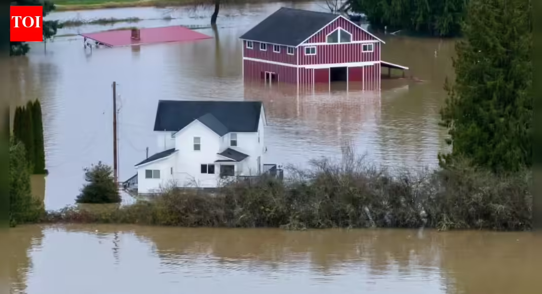
Western Washington has been hit by severe flooding after days of relentless rain inundated towns and forced evacuations. While heavy rain is common in the Pacific Northwest, officials and scientists say this event is different in scale and intensity. The main driver is a series of powerful atmospheric rivers. Understanding how they work helps explain why the flooding has been so widespread and destructive.
What exactly is an atmospheric river
An atmospheric river is a long, narrow band of cloud and moisture that forms over warm ocean waters and moves through the atmosphere like a flowing river in the sky. These systems can stretch thousands of kilometres while being only a few hundred kilometres wide. Despite their narrow shape, they transport staggering amounts of water vapour, often comparable to the flow of major rivers on the ground.When an atmospheric river makes landfall, that moisture has to fall somewhere. Depending on conditions, it can arrive as heavy rain or, at higher elevations, snow. In this case, unusually warm storm temperatures meant most of the moisture fell as rain.
Why Washington is especially vulnerable
Washington’s geography amplifies the impact of atmospheric rivers. Moist air moving inland from the Pacific is forced upward when it hits the Coast Range and the Cascade Mountains. As the air rises, it cools and releases its moisture, a process known as orographic lift. This turns already heavy rain into extreme rainfall over river basins.Low-lying valleys, such as those around the Skagit and Snohomish rivers, then funnel this water downstream. When rainfall is intense and prolonged, rivers rise rapidly and spill into surrounding communities.
Why this event turned into massive flooding
Several factors combined to make the flooding severe. The atmospheric rivers arrived back to back, meaning the ground had no time to dry between storms. Soils became saturated quickly, leaving little capacity to absorb additional rain. As a result, more water ran directly into rivers and streams.At the same time, river levels were already elevated from earlier rainfall. When the next surge of moisture arrived, water levels crossed flood thresholds and, in some cases, reached or exceeded historic records.
The role of stalled weather patterns
Another key reason for the scale of the flooding was that the storms did not move through quickly. A persistent weather pattern over the Pacific slowed the systems down, allowing the same areas to be hit repeatedly. Instead of one intense burst of rain followed by clearing conditions, communities experienced days of continuous downpours.This repeated loading of water is what turns heavy rain into a flood disaster. Each additional hour of rain compounds the pressure on rivers, levees and drainage systems.
Is climate change making atmospheric rivers worse
Scientists say climate change does not create atmospheric rivers, but it does make them more dangerous. Warmer air can hold more moisture, so as global temperatures rise, atmospheric rivers are able to carry and release more water.This means that when these systems hit land, rainfall rates are higher than in the past. In regions like the Pacific Northwest, that translates into greater flood risk, even if the number of storms does not dramatically increase.
What happens next as waters recede
As rainfall eases, rivers are expected to slowly fall, but risks do not disappear immediately. Saturated ground increases the chance of landslides, while damaged infrastructure and stressed levees remain vulnerable. Emergency officials continue to urge caution, particularly in low-lying and river-adjacent areas.